Växla navigering
Sök
Kenya
mer om detta
land
Afghanistan
Albanien
Algeriet
Amerikanska Samoa
Andorra
Angola
Anguilla
Antigua och Barbuda
Argentina
Armenia
Aruba
Australien
Azerbajdzjan
Bahamas,
Bahrain
Bangladesh
Barbados
Belgien
Belize
Benin
Bermuda
Bhutan
Bolivia
Bosnien och Hercegovina
Botswana
Brasilien
Brunei
Bulgarien
Burkina Faso
Burundi
Caymanöarna
Centralafrikanska republiken
Chad
Chile
Cocos (Keeling) Islands
Colombia
Cooköarna
COSTA RICA
Cote d `voire
Cypern
Danmark
Djibouti
Dominica
DOMINIKANSKA REPUBLIKEN
Ecuador
Egypten
Ekvatorial Guinea
El Salvador
Eritrea
Estland
Etiopien
Falklandsöarna (Islas Malvinas)
Faroe Islands
Fiji
Filippinerna
Finland
Frankrike
Franska Guyana
Franska Polynesien
Förenade Arabemiraten
Förenade kungariket Storbritannien
Gabon
Gambia, Den
Georgien
Ghana
Gibraltar
Grekland
Grenada
Grönland
Guadeloupe
Guam
Guatemala
Guernsey
Guinea
GUINEA-BISSAU
Guyana
Haiti
Honduras
Hong Kong
Indien
Indonesien
Irak
Iran
Irland
Island
Israel
Italien
Jamaica
Japan
Jemen
Jersey
Jordanien
JULÖN
Jungfruöarna (USA)
Kalkon
Kambodja
Kamerun
Kanada
Kap Verde
Kazakstan
Kenya
Kina
Kirgizistan
Kiribati
Komorerna
Kongo, Demokratiska republiken
Kroatien
Kuba
Kuwait
Laos
Lebanon
Lesotho
Lettland
Liberia
Libyen
Liechtenstein
Litauen
Luxemburg
Macau
Madagascar
Makedonien, fd jugoslaviska republiken
Malawi
Malaysia
Maldiverna
Mali
Malta
Marocko
Marshallöarna
Martinique
Mauretanien
Mauritius
Mayotte
Mexiko
Mikronesien av
Moldavien
Monaco
Mongoliet
Montenegro
Montserrat
Moçambique
Myanmar
Namibia
Nauru
Nederländerna
Nederländska Antillerna
Nepal
Nicaragua
Niger
Nigeria
Niue
Nordkorea
Nordmarianerna
Norfolkön
Norge
Nya Kaledonien
Nya Zeeland
Oman
Österrike
Östtimor
Pakistan
Palau
Panama
Papua Nya Guinea
Paraguay
Peru
Pitcairnöarna
Polen
Portugal
Puerto Rico
Qatar
Republiken Kongo om
Reunion
Rumänien
Rwanda
Ryssland
S: t Kitts och Nevis
Saint Helena
Saint Lucia
Saint Pierre och Miquelon
Saint Vincent och Grenadinerna
SALOMONÖARNA
Samoa
San Marino
Sao Tomé och Principe
SAUDI-ARABIEN
Schweiz
Senegal
Serbien
Seychellerna
Sierra Leone
Singapore
Slovakien
Slovenien
Somalia
Spanien
Sri Lanka
Sudan
Surinam
Svalbard
Sverige
Swaziland
Sydafrika
Sydkorea
Syrien
Tadzjikistan
Taiwan
Tanzania
Thailand
TJECKISKA REPUBLIKEN
Togo
Tokelauöarna
Tonga
Trinidad och Tobago
Tunisien
Turkmenistan
Turks-och Caicosöarna
Tuvalu
Tyskland
Uganda
Ukraina
Ungern
Uruguay
USA (USA)
Uzbekistan
Vanuatu
Venezuela
Vietnam
Vitryssland
Västsahara
Wallis-och Futunaöarna
Zambia
Zimbabwe
Nairobi
mer om detta
stad
Nairobi
Fri notering
Kontakter
Manyatta Airport
Kenya
List of airports Kenya
Manyatta Airport
Information om flygplats - Manyatta Airport, Kenya
Beskrivning
Värde
IATA
(International Air Transport Association flygplatskod)
Ingen IATA-kod
Typ
Liten flygplats
Lokala flygplatsen kodifierar
-
GPS flygplatskod
Longitud
-0.491196006536484
Latitude
36.3506546020508
Bilder nära Manyatta Airport, Kenya
Bilder Manyatta Airport
Informativt material - Nairobi
Priser, levnadskostnader Nairobi
Lokal tid i Nairobi
Tidszon - Nairobi, Kenya
Väder - Nairobi, Kenya
Karta över Nairobi
Nationella flagga Kenya
Nairobi - telefonkoden, hur ringer man till Nairobi
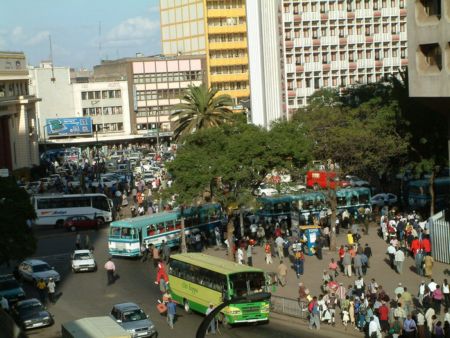
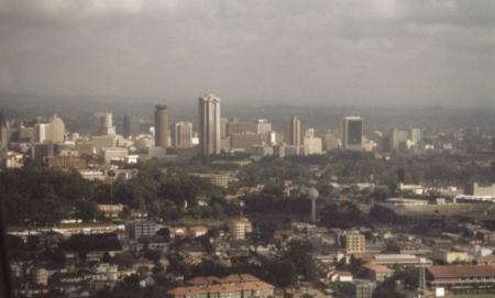
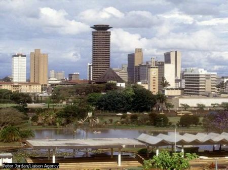
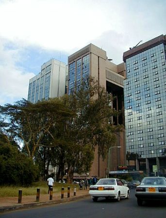
Bilder Nairobi
Avstånd från Nairobi, Kenya
Informativt material - Kenya
Valuta Kenya, Kenyanska Shilling
Valuta kalkylator Kenyanska Shilling
Ambassader Kenya
Karta över Kenya
Lista över flygplatser Kenya
Bildgalleri
Kenya, Nairobi
Lägg till ditt foto
Bilder Nairobi »