Växla navigering
Sök
Australien
mer om detta
land
Afghanistan
Albanien
Algeriet
Amerikanska Samoa
Andorra
Angola
Anguilla
Antigua och Barbuda
Argentina
Armenia
Aruba
Australien
Azerbajdzjan
Bahamas,
Bahrain
Bangladesh
Barbados
Belgien
Belize
Benin
Bermuda
Bhutan
Bolivia
Bosnien och Hercegovina
Botswana
Brasilien
Brunei
Bulgarien
Burkina Faso
Burundi
Caymanöarna
Centralafrikanska republiken
Chad
Chile
Cocos (Keeling) Islands
Colombia
Cooköarna
COSTA RICA
Cote d `voire
Cypern
Danmark
Djibouti
Dominica
DOMINIKANSKA REPUBLIKEN
Ecuador
Egypten
Ekvatorial Guinea
El Salvador
Eritrea
Estland
Etiopien
Falklandsöarna (Islas Malvinas)
Faroe Islands
Fiji
Filippinerna
Finland
Frankrike
Franska Guyana
Franska Polynesien
Förenade Arabemiraten
Förenade kungariket Storbritannien
Gabon
Gambia, Den
Georgien
Ghana
Gibraltar
Grekland
Grenada
Grönland
Guadeloupe
Guam
Guatemala
Guernsey
Guinea
GUINEA-BISSAU
Guyana
Haiti
Honduras
Hong Kong
Indien
Indonesien
Irak
Iran
Irland
Island
Israel
Italien
Jamaica
Japan
Jemen
Jersey
Jordanien
JULÖN
Jungfruöarna (USA)
Kalkon
Kambodja
Kamerun
Kanada
Kap Verde
Kazakstan
Kenya
Kina
Kirgizistan
Kiribati
Komorerna
Kongo, Demokratiska republiken
Kroatien
Kuba
Kuwait
Laos
Lebanon
Lesotho
Lettland
Liberia
Libyen
Liechtenstein
Litauen
Luxemburg
Macau
Madagascar
Makedonien, fd jugoslaviska republiken
Malawi
Malaysia
Maldiverna
Mali
Malta
Marocko
Marshallöarna
Martinique
Mauretanien
Mauritius
Mayotte
Mexiko
Mikronesien av
Moldavien
Monaco
Mongoliet
Montenegro
Montserrat
Moçambique
Myanmar
Namibia
Nauru
Nederländerna
Nederländska Antillerna
Nepal
Nicaragua
Niger
Nigeria
Niue
Nordkorea
Nordmarianerna
Norfolkön
Norge
Nya Kaledonien
Nya Zeeland
Oman
Österrike
Östtimor
Pakistan
Palau
Panama
Papua Nya Guinea
Paraguay
Peru
Pitcairnöarna
Polen
Portugal
Puerto Rico
Qatar
Republiken Kongo om
Reunion
Rumänien
Rwanda
Ryssland
S: t Kitts och Nevis
Saint Helena
Saint Lucia
Saint Pierre och Miquelon
Saint Vincent och Grenadinerna
SALOMONÖARNA
Samoa
San Marino
Sao Tomé och Principe
SAUDI-ARABIEN
Schweiz
Senegal
Serbien
Seychellerna
Sierra Leone
Singapore
Slovakien
Slovenien
Somalia
Spanien
Sri Lanka
Sudan
Surinam
Svalbard
Sverige
Swaziland
Sydafrika
Sydkorea
Syrien
Tadzjikistan
Taiwan
Tanzania
Thailand
TJECKISKA REPUBLIKEN
Togo
Tokelauöarna
Tonga
Trinidad och Tobago
Tunisien
Turkmenistan
Turks-och Caicosöarna
Tuvalu
Tyskland
Uganda
Ukraina
Ungern
Uruguay
USA (USA)
Uzbekistan
Vanuatu
Venezuela
Vietnam
Vitryssland
Västsahara
Wallis-och Futunaöarna
Zambia
Zimbabwe
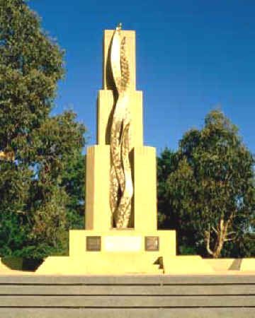
Canberra, ACT
mer om detta
stad
Adelaide, SA
Albany
Albury-Wodonga
Baird Bay, SA
Ballarat, VIC
Ballina
Bendigo
Brisbane, QLD
Bunbury
Bundaberg
Busselton
Byron Bay
Cairns, QLD
Canberra, ACT
Coffs Harbour
Darwin, NT
Devonport
Geelong
Geraldton
Gladstone-Tannum Sands
Gosford, NSW
Hervey Bay
Hobart, TAS
Kewarra beach
Launceston
Mackay, QLD
Melbourne, VIC
Mildura-Wentworth
Newcastle, NSW
Orange
Perth, WA
Port Macquarie
Ravenshoe, QLD
Rockhampton
Shepparton-Mooroopna
Sydney, NSW
Tamworth
Toowoomba
Townsville, QLD
Traralgon-Morwell
Wagga Wagga
Wollongong
Fri notering
Kontakter
Snowy Range Airfield
Australien
List of airports Australien
Snowy Range Airfield
Information om flygplats - Snowy Range Airfield, Australien
Beskrivning
Värde
IATA
(International Air Transport Association flygplatskod)
Ingen IATA-kod
Typ
Liten flygplats
Lokala flygplatsen kodifierar
-
GPS flygplatskod
Longitud
-37.3485734147
Latitude
146.766046286
Bilder nära Snowy Range Airfield, Australien
Bilder Snowy Range Airfield
Informativt material - Canberra, ACT
Priser, levnadskostnader Canberra, ACT
Lokal tid i Canberra, ACT
Tidszon - Canberra, ACT, Australien
Väder - Canberra, ACT, Australien
Karta över Canberra, ACT
Nationella flagga Australien
Canberra, ACT - telefonkoden, hur ringer man till Canberra, ACT
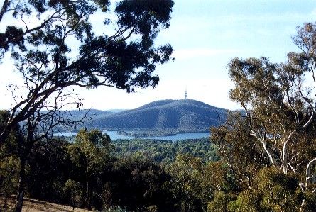
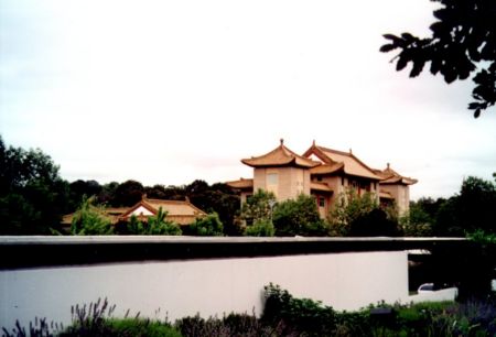
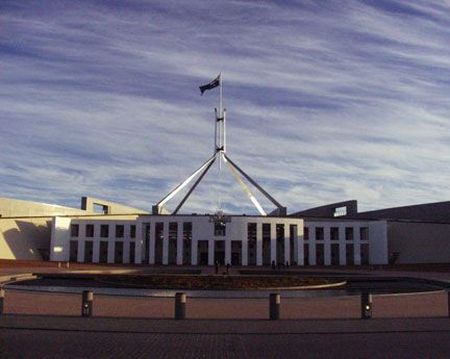
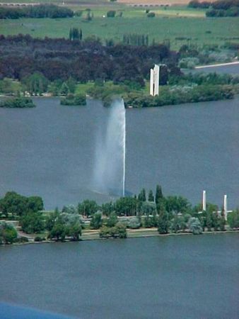
Bilder Canberra, ACT
Avstånd från Canberra, ACT, Australien
Informativt material - Australien
Valuta Australien, Australiensiska dollar
Valuta kalkylator Australiensiska dollar
Ambassader Australien
Karta över Australien
Lista över flygplatser Australien
Bildgalleri
Australien, Canberra, ACT
Lägg till ditt foto
Bilder Canberra, ACT »